A shift of just a few degrees in average temperature, or a decades-long change in rainfall patterns, can help build a city, weaken an empire, or push families to leave land their ancestors farmed for centuries. Human geography is not only about borders and cities; it is also about the slow environmental changes that make some places more productive, more dangerous, or less reliable over time.
To understand migration and settlement, geographers look at the relationship between people and the environment across different scales. A local drought may force farmers to move to a nearby town. A regional drying trend may reshape national economies. A global climate shift can alter food systems, trade networks, and population distribution across continents. The key question is not simply whether climate changes, but how long-term variability changes opportunities, risks, and choices.
Climate is the long-term pattern of temperature, precipitation, wind, and seasonal conditions in a place. Weather changes from day to day, but climate is measured over decades. Long-term climate variability includes recurring wet and dry periods, warming and cooling phases, monsoon shifts, and changes in storm frequency that last for many years, generations, or even centuries.
Long-term climate variability refers to natural or human-induced climate fluctuations that occur over long periods of time, from decades to millennia.
Migration is the movement of people from one place to another, either temporarily or permanently.
Settlement pattern describes the way people distribute themselves across a landscape, including villages, cities, dispersed farms, and dense urban regions.
Land use means how humans use land for farming, grazing, forestry, housing, industry, transportation, or conservation.
Long-term climate variability matters because human systems depend on environmental stability. Crops require predictable growing seasons. Herding depends on grass and water. Ports and river cities depend on reliable waterways. Even modern urban regions depend on reservoirs, energy systems, and transportation networks that were designed around past climate patterns.
Geographers also study scale. At the local scale, climate may influence whether a community plants wheat or raises cattle. At the regional scale, it may shift population toward river valleys or coastlines. At the global scale, it can influence major migration streams, food prices, and political tensions. The same climate trend can therefore produce different outcomes depending on location, wealth, technology, and government response.
Not all climate change is identical. Some changes are short-lived, like a single severe drought. Others are long-term patterns such as repeated monsoon failure, multi-decade cooling, or persistent warming. Geographers distinguish between climate variability, which includes natural fluctuations over time, and longer-term directional warming linked strongly to human greenhouse gas emissions. In the real world, however, these can overlap.
Important types of variability include shifts in rainfall, average temperature, season length, river flow, snowpack, storm tracks, and ocean conditions. These variables shape environmental productivity. If rainfall declines over decades, grasslands may support fewer animals. If winters become milder, farming zones may move poleward. If glaciers shrink, rivers that once fed cities and farms may become less dependable later in the year.
Climate affects people indirectly through geographic systems. Most long-term climate impacts are not direct effects of temperature alone. They work through water supply, crop yield, pasture quality, wildfire risk, disease environments, transportation routes, and disaster frequency. This is why geographers study connections among physical geography, population, economics, and political decision-making together.
One useful idea is carrying capacity, the number of people or animals an environment can support without severe degradation. Long-term drying can reduce carrying capacity by lowering water supply and soil productivity. In contrast, a wetter period may temporarily increase agricultural output and encourage settlement expansion. Yet expansion during good years can create future vulnerability if the climate shifts back.
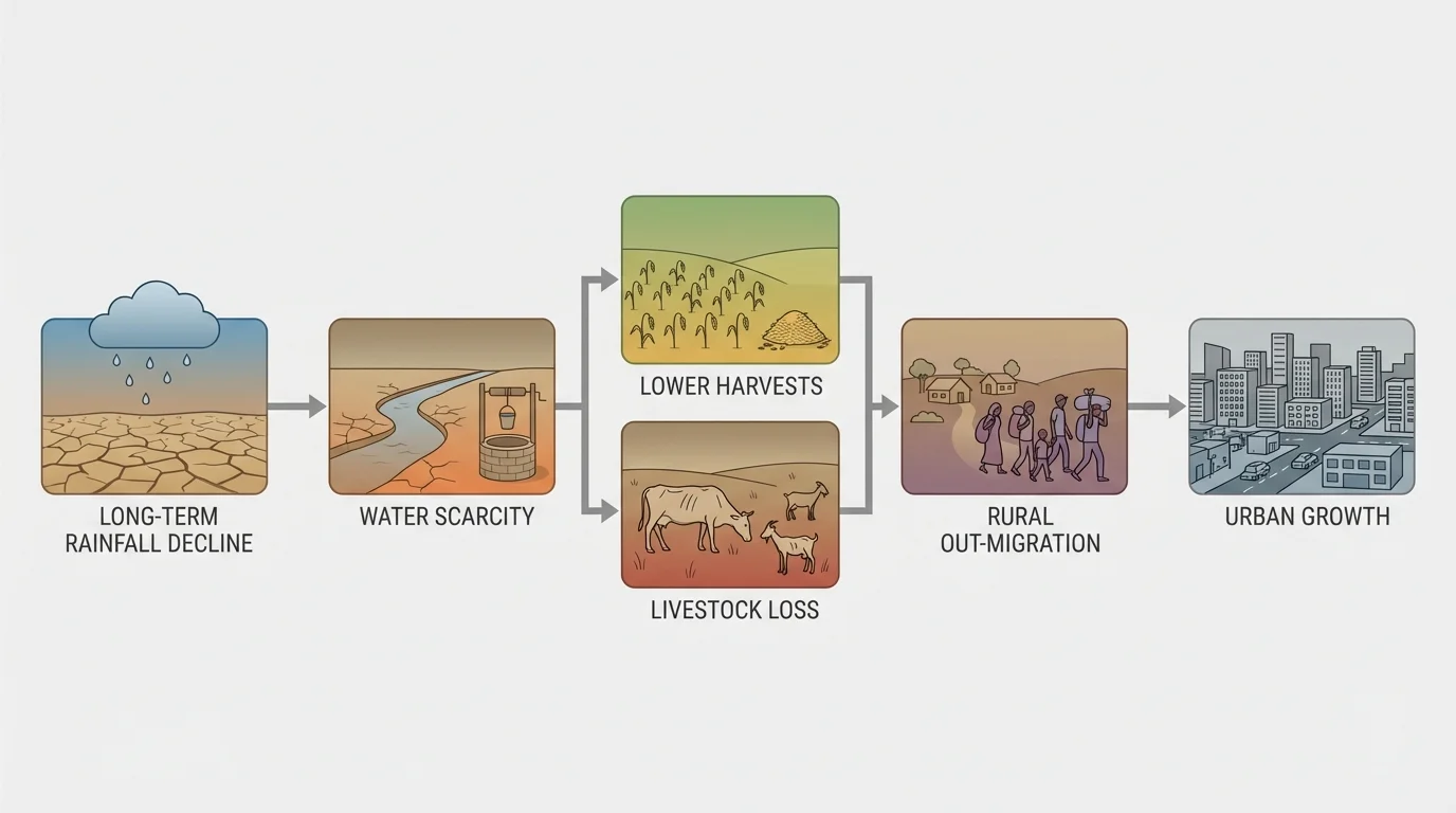
[Figure 1] Climate influences movement through both push factors and pull factors. Declining harvests, water shortages, repeated floods, and land degradation can push people out of an area. More reliable rainfall, job opportunities in safer cities, or access to irrigation can pull people toward other places. This chain of effects is easier to see when climate is linked to livelihoods through the sequence from environmental stress to migration.
Migration is rarely caused by climate alone. A family may stay during drought if it has savings, government support, irrigation, or alternative income. Another family may leave quickly if crops fail and debt increases. For this reason, geographers evaluate climate as one variable interacting with income, transportation, social networks, land ownership, and state policy.
Settlement patterns change when environmental conditions repeatedly reward some places and punish others. River valleys, monsoon margins, coastal plains, and temperate lowlands have often attracted dense settlement because they offer water, fertile soils, or access to trade. By contrast, regions with repeated drought, permafrost change, desertification, or sea-level rise may lose population or require expensive adaptation.
Rural-to-urban migration is one common response. When farms and grazing systems become less reliable, people often move first to nearby towns, then to larger cities. This can create rapid urban growth, especially in countries where agriculture remains a major source of employment. In other situations, climate variability encourages seasonal mobility rather than permanent relocation. Pastoral communities may change routes, timing, or herd size instead of fully abandoning a region.
Physical geography also matters. Mountain communities may depend on snowmelt. Delta settlements depend on sediment and river flow. Island settlements are sensitive to freshwater supply. In each case, long-term climate variability changes the environmental base that supports settlement.
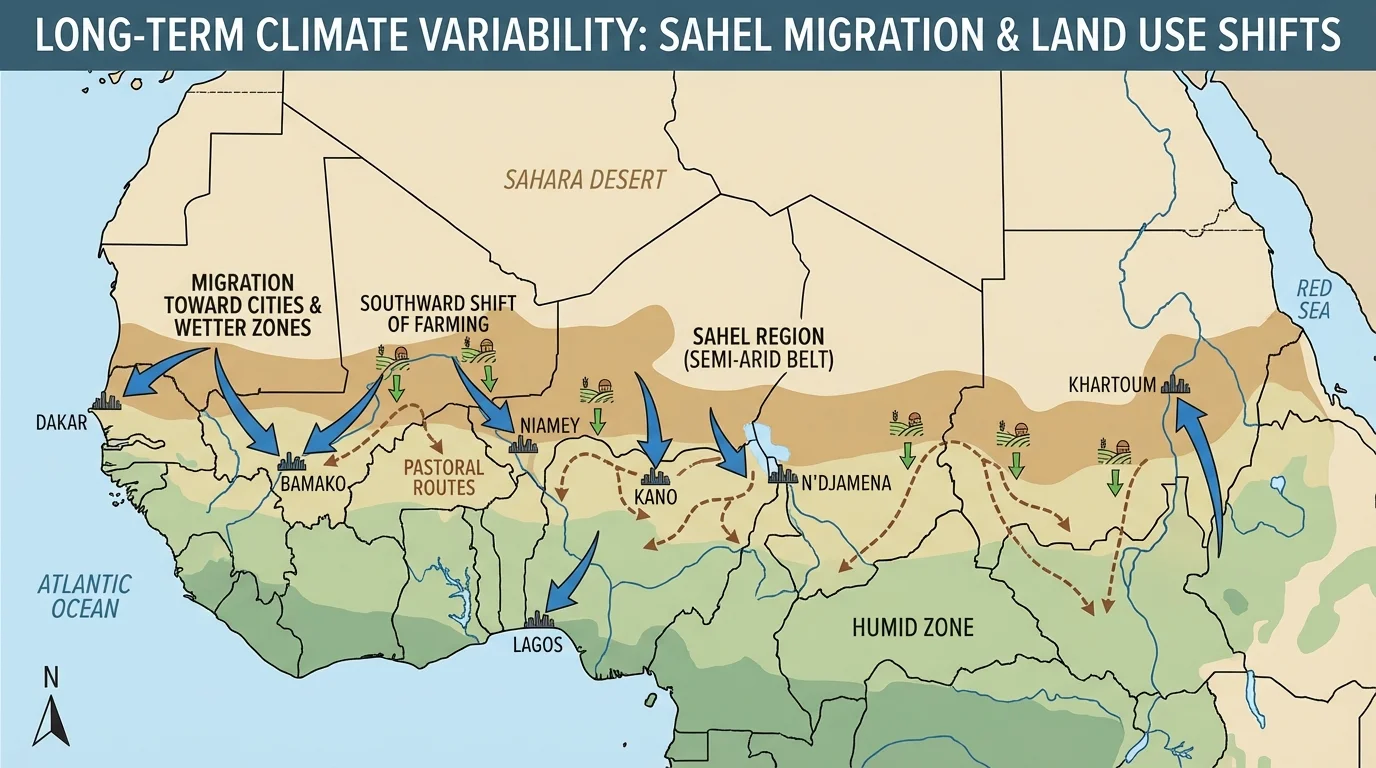
[Figure 2] In the Sahel, the semi-arid belt south of the Sahara, long-term rainfall variability has strongly shaped farming, herding, and migration through shifting ecological zones and movement patterns. During severe drought decades in the late twentieth century, crop failures and livestock deaths increased food insecurity and pushed many people toward cities or wetter southern areas.
The Sahel is a clear example of how climate interacts with land use. Pastoralists need flexible access to grazing land, while farmers may expand cultivation during wetter periods. When rainfall drops again, competition over land and water can intensify. Population growth, state boundaries, and conflict can then turn climate stress into political crisis. Here, migration may be temporary, circular, or permanent depending on household resources and security conditions.
Another major example is the Dust Bowl of the 1930s in the United States. Although it was not only a climate event, prolonged drought combined with poor farming practices and exposed topsoil created massive dust storms on the Great Plains. Thousands of families left Oklahoma, Texas, Kansas, and surrounding areas for places such as California. This case shows that climate variability becomes far more destructive when land is used unsustainably.
In the modern American Southwest, long-term aridity and repeated drought influence urban growth, agriculture, and water transfers. Cities such as Phoenix and Las Vegas exist partly because technology and infrastructure bring water from distant sources. But these adaptations have limits. Reduced snowpack in the Rocky Mountains and lower river flow in the Colorado River basin create pressure on cities, farms, and ecosystems. Settlement remains possible, yet the cost and complexity of maintaining it increase.
Case study comparison: climate stress and migration
Step 1: Identify the environmental change.
In the Sahel, the major change is repeated long-term rainfall decline and variability. In the Dust Bowl, prolonged drought combined with topsoil exposure.
Step 2: Identify the livelihood affected.
In the Sahel, farming and herding are directly affected by water and pasture loss. In the Great Plains, mechanized agriculture suffered from soil erosion and crop failure.
Step 3: Identify the migration pattern.
In the Sahel, many people moved to cities, coastal states, or wetter regions, often in stages. In the Dust Bowl, many households migrated westward, especially to California.
Step 4: Evaluate human choices.
In both cases, climate stress mattered, but land management, policy, transportation, and economic opportunity shaped the final outcome.
The comparison shows that climate rarely acts alone; it operates through human systems.
These examples remind us that a local climate shift can trigger broader regional effects. A drought in one farming zone may raise food prices elsewhere, draw migrants into cities, and change land values over a much larger area.
[Figure 3] Across history, long-term climate shifts have repeatedly changed settlement systems through major warming and cooling periods linked to human adjustment. After the last Ice Age, warming during the early Holocene created conditions that supported agriculture in several world regions. More reliable growing conditions encouraged more permanent settlements, larger populations, and eventually urban civilizations.
Monsoon variability has also shaped the history of South Asia, East Asia, and parts of Africa. Stronger or weaker monsoons alter river flow, crop yields, and water storage. In societies heavily dependent on seasonal rains, a series of weak monsoons can contribute to famine, debt, migration, and political instability.
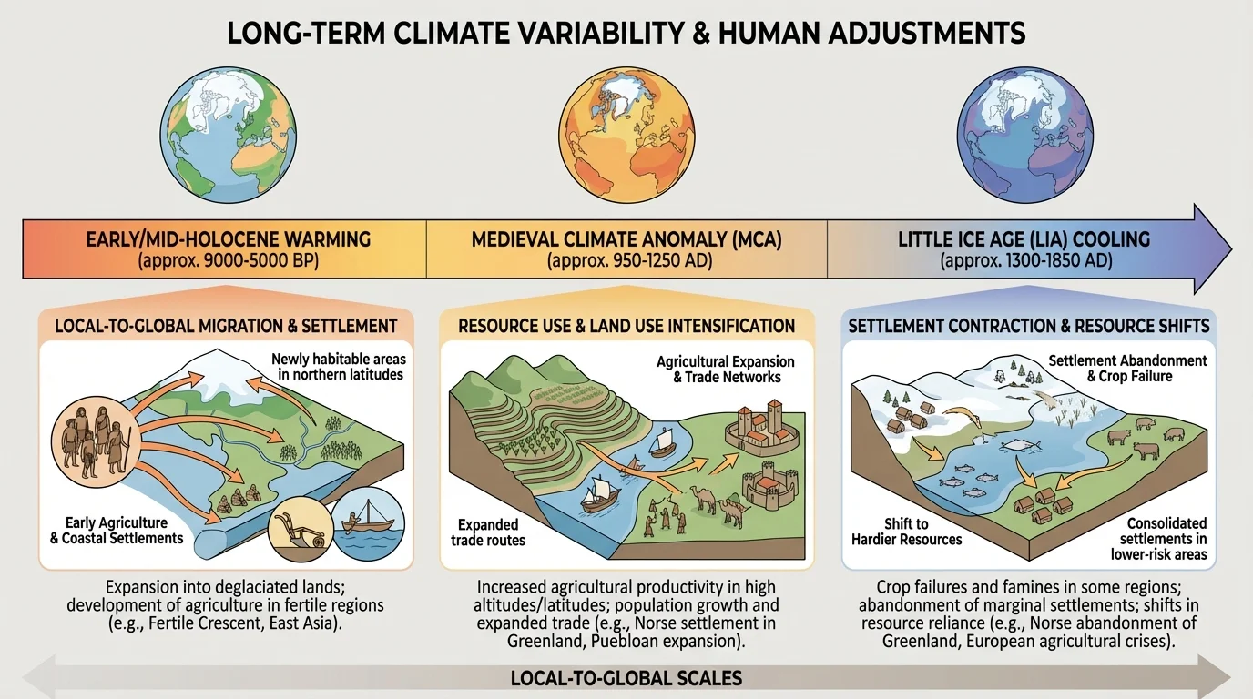
During the Little Ice Age, a period of cooler conditions from roughly the fourteenth to nineteenth centuries, some regions experienced shorter growing seasons, harsher winters, and crop failures. In Europe, this contributed to stress in rural communities and influenced food prices and social tension. In mountain and northern regions, settlement and agriculture were more difficult. While climate was not the only cause of hardship, it amplified existing vulnerabilities.
In Greenland, Norse settlements struggled as climate cooled, sea ice increased, and trade connections weakened. This is an important example because it shows how environmental pressure can combine with isolation and limited adaptation. Settlements that worked under one climate regime may become much harder to sustain under another.
Climate-linked mobility is also visible in dryland regions of Central Asia, in shifting agricultural zones in China, and in movement around lake basins and river systems in Africa. Over centuries, populations have moved toward reliable water, fertile soils, and stable trade routes. When those geographic advantages weaken, migration often follows.
| Region | Long-term climate pattern | Common human response | Effect on settlement |
|---|---|---|---|
| Sahel | Recurring drought and rainfall variability | Pastoral mobility, urban migration, crop change | Pressure on dryland villages; growth of towns and southern zones |
| Great Plains | Multi-year drought | Out-migration, soil conservation reforms | Abandonment of some farms; reorganization of agriculture |
| South Asia | Monsoon variability | Irrigation, migration for work, crop adjustment | Population concentration in irrigated and river-fed regions |
| Arctic | Warming and sea ice loss | Adaptation in transport and hunting, some relocation | Changing viability of traditional settlements |
| Mediterranean | Long-term drying in some areas | Water storage, crop shifts, rural decline in stressed zones | Greater strain on agriculture and urban water systems |
Table 1. Examples of how long-term climate patterns influence human responses and settlement outcomes in different world regions.
[Figure 4] Climate variability changes not only where people live but also how they use resources. Water is often the most important factor. When rivers shrink, groundwater becomes more valuable. When rainfall becomes less predictable, irrigation expands, reservoirs are built, and competition grows among farms, cities, and ecosystems. The contrast between wetter and drier land-use strategies compares how societies adjust production and water management.
Land use often shifts in response to risk. Farmers may replace water-intensive crops with drought-resistant varieties. Ranchers may reduce herd sizes. Forest use may intensify if farming declines, or forests may be cleared when people migrate into wetter frontiers. In some places, dry years lead to overgrazing and soil erosion. In others, better planning leads to terracing, conservation tillage, and more efficient irrigation.
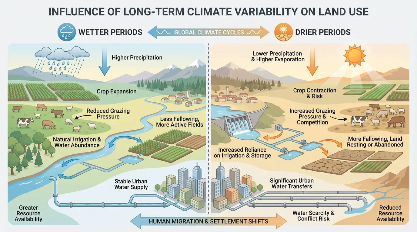
Land-use change can create feedback loops. For example, when drought encourages overuse of fragile soils, land degradation may worsen future vulnerability even if rainfall improves. Similarly, expanding irrigation may support settlement in the short term but deplete aquifers in the long term. Geographers therefore evaluate sustainability, not just immediate survival.
One major process is desertification, the degradation of dryland ecosystems caused by a combination of climate stress and human pressure. Desertification does not mean a place suddenly becomes a desert. Instead, it means the land loses productivity because vegetation, soil, and water systems are damaged. This can lower food production, increase dust, and encourage migration.
Some of the world's most productive farming regions depend on water stored as mountain snow and ice. When warming reduces snowpack, cities and farms downstream may receive less water during the dry season, even if annual precipitation does not fall dramatically.
Fisheries also respond to long-term climate variability. Ocean temperature changes can alter species distribution, affecting where fishing communities work and settle. In high-latitude regions, warming may open new shipping or fishing opportunities while threatening existing ecosystems and Indigenous ways of life. Climate can therefore change resource use on land and at sea.
Geography is about relationships. Climate interacts with topography, soil, vegetation, water systems, infrastructure, technology, government policy, and culture. A drought in a wealthy country with reservoirs, insurance, and transportation may produce different migration outcomes from a similar drought in a poorer country with limited state support.
This is why geographers analyze adaptation, which means adjusting practices or systems to reduce harm or take advantage of changing conditions. Adaptation includes crop switching, water-saving technology, hazard planning, migration networks, raised housing in flood-prone zones, and legal agreements over water sharing. Adaptation can reduce displacement, but unequal access to resources means not everyone can adapt equally well.
Economic globalization also matters. If local farmers lose income due to climate stress, family members may migrate internationally and send remittances back home. These funds can support households, pay for water systems, or finance relocation. In this way, a local environmental problem can become part of a global migration system.
Climate vulnerability is uneven. Two communities may face the same environmental trend but experience very different outcomes. Vulnerability depends on exposure to the hazard, sensitivity of livelihoods, and capacity to adapt. Areas with poverty, weak infrastructure, or political instability often experience greater migration pressure under the same climate conditions.
Cultural values matter too. Some communities remain in place despite increasing environmental risk because of identity, sacred land, family ties, or legal barriers to movement. Others have traditions of mobility that make seasonal migration a normal adaptation rather than a crisis response.
To evaluate climate influence accurately, geographers use many kinds of evidence: rainfall records, tree rings, lake sediments, glacier data, census counts, land-cover maps, agricultural statistics, and migration surveys. No single source tells the whole story. For older periods, scientists often rely on climate proxy evidence such as pollen, ice cores, or tree rings to reconstruct past conditions.
It is important not to oversimplify. Saying "climate caused migration" can be misleading if war, land policy, debt, or discrimination were also major drivers. A stronger evaluation asks how much climate mattered, through which pathways, and at what scale. For example, climate may weaken food security, which increases competition, which then contributes to conflict and migration. In that chain, climate is influential but indirect.
The same figure of environmental change can produce multiple outcomes. In one region, people relocate. In another, they intensify irrigation. Elsewhere, governments build dams or import food. Therefore, geographic analysis focuses on interaction rather than simple cause and effect. The flow of impacts first introduced in [Figure 1] is useful here because it shows how climate pressure moves through livelihoods and institutions before changing settlement patterns.
Long-term climate variability is not only a historical issue. It shapes current debates about water rights, urban planning, food security, wildfire management, coastal retreat, and cross-border migration. As average conditions change and variability intensifies in some places, the boundaries between normal climate fluctuation and long-term transformation become harder to separate.
Many governments now use geographic data to plan for future settlement and resource use. They map flood risk, monitor drought, redesign crop zones, and identify communities that may need relocation assistance. In dry regions, planners ask whether continued growth is sustainable under reduced water supply. In coastal regions, they ask how rising hazard exposure may reshape land values and population distribution.
The big geographic lesson is that climate does not affect empty space; it affects lived landscapes. Villages, cities, farms, ports, forests, and transportation systems are all built within environmental limits. When those limits shift over decades or centuries, people move, adapt, compete, and redesign land use. Some societies become more resilient. Others face displacement, inequality, and conflict. Evaluating these patterns at local, regional, and global scales helps us understand not only the past, but also the choices being made right now.