A city rises where a swamp once stood. A desert becomes a farming region. A river is forced through turbines to power millions of homes. These changes can look like human triumph over nature, but geography asks a deeper question: who benefits, who pays the price, and how long do the benefits last? Across the world, people have altered land, water, vegetation, and even coastlines to create wealth and security. Yet the same actions that produce food, energy, jobs, and transportation can also damage ecosystems, displace communities, and create long-term environmental dilemmas.
Geography studies the relationships among people, places, and environments. One of its central ideas is human-environment interaction: people depend on the environment, adapt to it, and modify it. Environmental change is not random. It is shaped by geographic variables such as climate, soil, water availability, natural resources, population density, technology, and government policy.
When people alter an environment, they usually do so for practical reasons. They may clear forests for farmland, drain wetlands for housing, build dams for irrigation and electricity, dredge harbors for trade, or mine mountains for minerals. In many cases, these actions create immediate prosperity. Crops increase, transport improves, factories open, and property values rise. But environments are connected systems. Changing one part of a system often affects another part in ways that are hard to reverse.
Prosperity means economic well-being, including increased income, jobs, infrastructure, and access to goods and services. An environmental dilemma is a difficult situation in which actions that bring benefits also create ecological or social costs that are hard to solve without giving something up.
This is why geographers often focus on trade-offs. A dam may reduce flooding and generate power, but it can also block fish migration. Irrigation canals may turn dry land green, but they can deplete rivers and increase soil salinity. A port city may thrive because engineers reshape the coastline, but those same changes can increase vulnerability if sea levels rise or storms intensify.
People modify environments because they are trying to solve geographic problems. A dry region may not have enough rainfall for crops. A low-lying coast may flood too easily for large settlements. A mountainous area may be rich in minerals but difficult to access. A rapidly growing city may need more land, more water, and more energy than the natural setting can easily provide.
Economic motives are especially powerful. If changing the environment increases agricultural output, supports trade, or unlocks valuable resources, governments and businesses often see it as worthwhile. In some regions, environmental engineering has transformed local economies. Irrigation helped support agricultural growth in parts of the American West. River control projects improved transportation and electricity access in the Tennessee Valley. The Netherlands protected farmland and cities through dikes, pumps, and reclaimed land. In each case, prosperity depended on altering natural conditions rather than simply accepting them.
At the same time, what counts as success depends on scale and time. A project may appear successful over five years but create major problems over fifty. It may bring wealth to investors and urban residents while harming rural communities, indigenous peoples, or downstream ecosystems. Geographic thinking requires looking beyond the immediate result.
The Netherlands has reclaimed large areas of land from water for centuries. Some parts of the country lie below sea level, yet engineering systems have made them productive places to live, farm, and trade.
Environmental change also reflects power. Groups with more money, technology, and political influence usually have more ability to redesign landscapes. That means environmental benefits and environmental burdens are rarely shared equally.
Irrigation is one of the clearest examples of environmental alteration bringing both prosperity and serious risk. By redirecting water through canals, reservoirs, wells, and pumps, people can grow crops in regions that receive too little rainfall naturally. Changing the movement of water can transform a dry basin into productive farmland while also weakening downstream ecosystems that depend on that same water.
In places such as California's Central Valley, irrigation has supported one of the most productive agricultural regions in the world. Farmers grow almonds, grapes, tomatoes, lettuce, and many other crops at a massive scale. This creates jobs, export income, food processing industries, and transportation networks. Similar patterns appear in parts of India, Pakistan, Egypt, and northern China, where river water or groundwater has made large-scale farming possible.
However, irrigation often creates environmental dilemmas. One major problem is salinization, which happens when water evaporates and leaves salts behind in the soil. Over time, the soil becomes less fertile, and crop yields can decline. Another problem is groundwater depletion, in which water is pumped from underground aquifers faster than it can be naturally replaced. This can cause wells to dry up and land to sink.
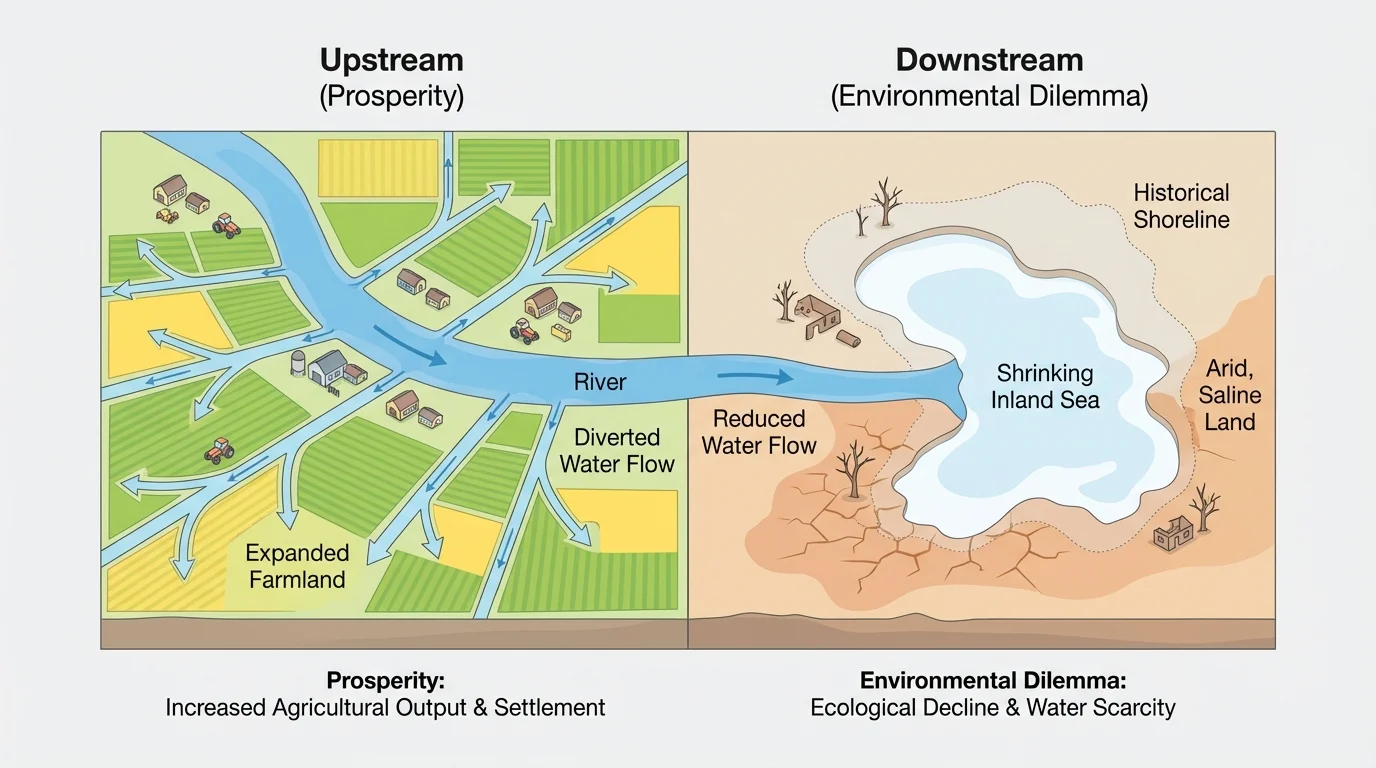
The Aral Sea in Central Asia is a dramatic case. During the Soviet period, rivers that fed the sea were heavily diverted to irrigate cotton fields in Kazakhstan and Uzbekistan. In the short term, this supported agricultural production and state economic goals. In the long term, the Aral Sea shrank drastically. Fisheries collapsed, exposed lakebed released salty dust, local climates changed, and public health suffered. Water engineering had created prosperity for some sectors, but environmental damage spread across the region.
The same geographic process can therefore have opposite outcomes depending on management. Efficient irrigation systems, crop choices suited to climate, and limits on water withdrawal can reduce harm. But when governments or businesses pursue short-term gains without protecting the wider system, the environmental costs grow.
Why water projects are so powerful
Water connects many geographic variables at once. It influences agriculture, settlement, transportation, energy, ecosystems, and public health. Because of this, altering water systems often produces large benefits quickly, but it also creates ripple effects across entire regions.
Later discussions about sustainability return to this lesson: redirecting water never affects only one field or one town. It reshapes whole drainage systems.
Urban prosperity often depends on environmental engineering, as [Figure 2] illustrates through the example of coastlines, drainage, and reclaimed land. Many important cities occupy locations that are economically valuable but environmentally difficult: river deltas, low coasts, floodplains, steep hillsides, or deserts. To support large populations and economic activity, people modify these settings.
Consider the Netherlands. Much of the country faces flood risk from the North Sea and major rivers. Through dikes, storm barriers, canals, pumps, and reclaimed polders, Dutch engineers created land suitable for farming, housing, and industry. This helped support one of Europe's strongest trading economies. Rotterdam became one of the world's major ports partly because the surrounding environment was carefully controlled and redesigned.
Land reclamation has also supported urban growth in places such as Singapore, Hong Kong, and Dubai. In Dubai, dredging and coastal construction helped create new real estate, tourist districts, and port facilities. These projects increased investment and global visibility. Yet they also disturbed marine habitats, changed coastal currents, and required enormous energy and water inputs in an already arid environment.
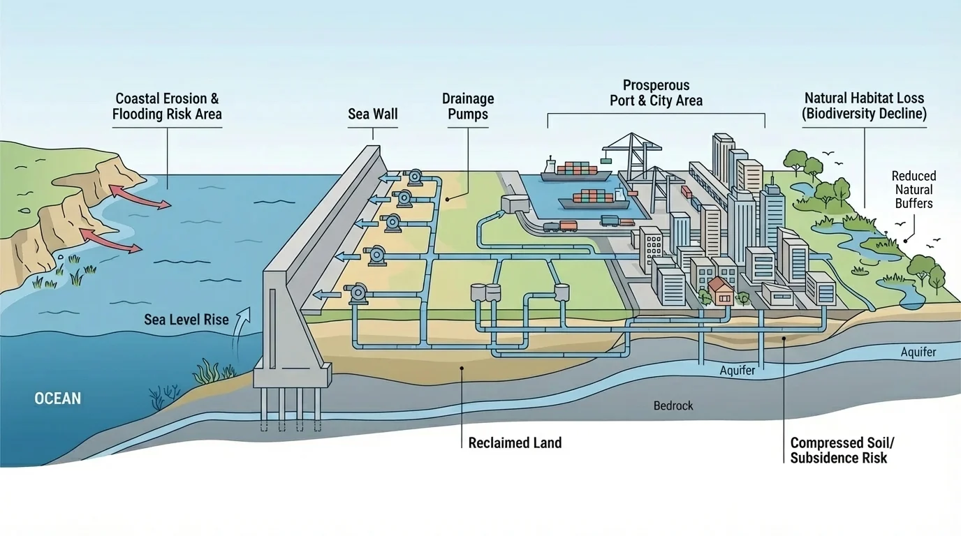
Draining wetlands for urban development is another common strategy. Wetlands may be seen as unused land, but they perform valuable ecological functions: storing floodwater, filtering pollutants, and supporting biodiversity. When cities remove them, they often gain space for roads, airports, and neighborhoods. At the same time, they lose natural protection against flooding. This is one reason some rapidly growing coastal cities now face severe flood risk during storms.
New Orleans shows the complexity of this process. Levees, drainage systems, and river management made expansion possible in areas that naturally flood. These changes brought economic growth and urban development. But the loss of wetlands and heavy dependence on engineered protection increased vulnerability when Hurricane Katrina struck in 2005. Human alteration had created a prosperous city in a difficult location, yet it also magnified environmental risk.
The long-term challenge is not simply whether humans can build in difficult places. It is whether they can do so in ways that remain safe and environmentally sound over time. The engineered coast shown in [Figure 2] makes clear that modern cities often depend on constant maintenance, energy use, and monitoring.
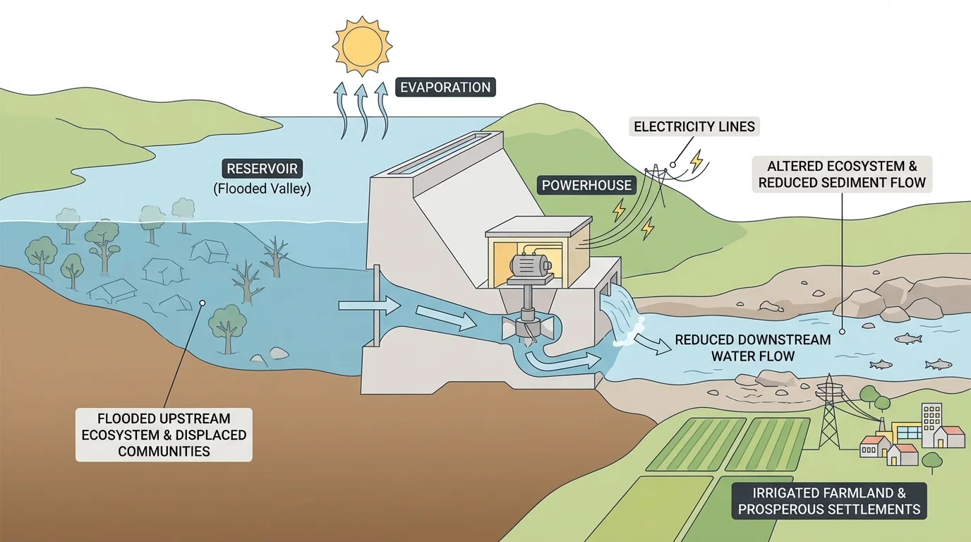
[Figure 3] Industrial development frequently begins with major environmental modification. A hydroelectric dam, open-pit mine, oil field, or industrial corridor changes the physical landscape so that energy and resources can be produced on a larger scale. One project can connect water storage, electricity generation, transportation, and settlement patterns all at once.
Dams are a powerful example. They can generate electricity without burning fossil fuels, reduce seasonal flooding, store water for dry periods, and support irrigation. The Tennessee Valley Authority in the United States used a system of dams and infrastructure projects during the twentieth century to expand electrification, improve navigation, control floods, and stimulate regional development. In this case, environmental alteration contributed to economic modernization and higher living standards.
Yet dams also create environmental dilemmas. Reservoirs flood valleys and forests, forcing people and wildlife to relocate. Sediment that would naturally move downstream gets trapped behind the dam. Fish migration can be interrupted. Water temperature and flow patterns change. Downstream farms and wetlands may receive fewer nutrients. In some tropical reservoirs, decaying vegetation can even release methane, a greenhouse gas.
Mining and drilling show a similar pattern. Coal, copper, iron, lithium, and oil have fueled industrial growth, technology production, and national wealth. Cities and transport systems often develop around extraction zones. But open-pit mining removes vegetation and topsoil, increases erosion, and can pollute water with heavy metals. Oil drilling can bring jobs and export earnings while risking spills and habitat damage. In the Niger Delta, for example, petroleum extraction generated major revenue for Nigeria, but pollution and conflict affected many local communities.
Industrial prosperity is therefore deeply geographic. It depends on where resources are located, how accessible they are, what technologies exist, and what regulations govern extraction. The same resource that enriches one region can leave another with contamination, health hazards, and damaged land.
Case study: Three Gorges Dam in China
This project shows why geographic analysis must include both gains and costs.
Step 1: Identify the prosperity created.
The dam generates massive amounts of electricity, improves river navigation, and helps control flooding along the Yangtze River.
Step 2: Identify the environmental and social dilemmas.
The reservoir flooded large areas, displaced more than a million people, and altered habitats and sediment movement.
Step 3: Evaluate the trade-off geographically.
The benefits are national and regional, but many costs are concentrated upstream and downstream in specific local places.
The key lesson is that environmental alteration often redistributes both opportunity and risk rather than eliminating either one.
When students evaluate projects like this, they should ask not only, "Did it work?" but also, "For whom, where, and for how long?" That is the core of geographic reasoning.
[Figure 4] The global pattern is visible across very different environments. Some places gain farmland from the sea, some gain wealth from desert construction, some gain electricity from rivers, and some lose ecological stability when short-term development overwhelms natural systems.
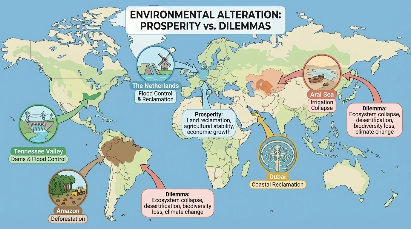
The Netherlands: Dikes, pumps, and polders created secure land for agriculture, cities, and trade. This is a classic case of environmental engineering supporting prosperity. However, the system requires constant upkeep and is increasingly challenged by sea-level rise and stronger storms.
Dubai: Urban and coastal reshaping supported tourism, real estate, and port development. Yet these achievements depend on imported resources, desalinated water, and heavy energy use in a desert climate.
The Tennessee Valley: River management, electrification, and infrastructure reduced poverty and expanded industry. At the same time, dam systems changed river ecology and landscapes across the region.
The Amazon Basin: Deforestation for cattle ranching, soy farming, logging, and roads has created economic gains for landowners and export sectors. But it has also reduced biodiversity, increased carbon emissions, threatened indigenous communities, and weakened one of the world's most important forest systems.
The Aral Sea region: Large irrigation schemes expanded cotton production but caused one of the world's most severe environmental disasters. This case makes it clear that altered environments can produce both prosperity and environmental crisis within the same broad region.
The Amazon rainforest helps regulate climate far beyond South America because its trees store carbon and influence atmospheric moisture. Local land-use change can therefore have global effects.
One of the most important geographic insights is that environmental change is uneven. Benefits and harms are not spread equally across space. A city may gain electricity from a dam while rural villages lose land to a reservoir. A nation may earn export income from mining while nearby communities face polluted streams. A coastal resort may attract investment while fishers lose access to traditional waters.
This unevenness is connected to environmental justice, the idea that no group should bear an unfair share of environmental harm. Often, poorer communities or politically marginalized groups have less power to resist harmful projects. They may also have fewer resources to recover when environmental damage occurs.
Scale matters too. A project that benefits a national economy may still harm a local ecosystem. Short-term profits can hide long-term losses. If a forest is cut faster than it can regrow, economic growth may be temporary. If a river is overused, agricultural expansion may eventually reduce itself by exhausting the water supply.
This is why geographers connect environmental change to politics, economics, and culture. Decisions about land and water are not only physical decisions. They involve values, priorities, and power relationships.
"We do not inherit the Earth from our ancestors; we borrow it from our children."
— Commonly cited environmental principle
The quote is not a scientific law, but it captures an important geographic truth: environmental alteration should be judged not only by immediate gain, but by whether it leaves future generations with functioning ecosystems and livable places.
To evaluate altered environments, geographers use multiple kinds of evidence. Economic data may include crop yield, employment, port traffic, electricity output, or gross domestic product. Environmental data may include water quality, air pollution, biodiversity, soil fertility, groundwater levels, and carbon emissions. Looking at just one indicator can be misleading.
| Type of Environmental Alteration | Possible Prosperity | Possible Dilemma |
|---|---|---|
| Irrigation | Higher crop production, food supply, export income | Salinization, river depletion, groundwater loss |
| Dams | Electricity, flood control, irrigation, navigation | Displacement, habitat loss, blocked sediment and fish movement |
| Land reclamation | Urban growth, ports, housing, industry | Wetland loss, flood risk, coastal ecosystem damage |
| Deforestation | Timber, farmland, roads, short-term profits | Biodiversity loss, erosion, carbon emissions |
| Mining and drilling | Jobs, revenue, industrial development | Pollution, landscape damage, health risks |
Table 1. Major forms of environmental alteration and their common benefits and costs.
Sustainability means meeting present needs without destroying the ability of future generations to meet theirs. In practice, this involves planning that respects environmental limits. Examples include drip irrigation that reduces water waste, fish ladders around dams, wetland restoration near cities, stricter pollution controls, protected areas, and environmental impact assessments before major projects begin.
Not every dilemma can be solved completely. Sometimes geographers and policymakers must compare imperfect options. But better planning can reduce the trade-offs. The goal is not to stop all environmental change. It is to understand systems well enough to create prosperity without causing avoidable damage.
Applying geographic thinking
A government wants to build a new dam in a semi-arid region.
Step 1: Identify geographic variables.
Key variables include rainfall patterns, river flow, nearby settlements, soil conditions, existing ecosystems, and energy demand.
Step 2: Predict benefits.
The dam may provide irrigation water, reduce seasonal flooding, and increase electricity supply.
Step 3: Predict dilemmas.
The reservoir may flood farmland or villages, alter fish habitats, and reduce downstream water availability.
Step 4: Make a better decision.
Leaders can compare alternative sites, add environmental safeguards, and consult affected communities before construction.
This process shows how geography links physical systems with human choices.
The most important idea is connection. Climate affects water supply. Water supply affects farming. Farming affects settlement and trade. Trade affects urban growth. Urban growth affects energy demand. Energy production affects rivers, forests, and air quality. Geography studies these linked systems rather than treating them as separate topics.
Altering the environment has brought real prosperity to many places. Fertile farmland, major ports, electrified regions, and powerful industrial economies often exist because humans reshaped natural landscapes. But these same actions have created serious dilemmas when they ignored ecological limits or distributed harm unfairly. The lesson of geography is not that environmental change is always good or always bad. It is that every change takes place in a specific location, with specific conditions, and with consequences that spread across space and time.
When students analyze environmental change, they should think like geographers: compare places, trace cause and effect, study maps and data, and ask how natural and human systems influence each other. Prosperity and environmental stress are often two sides of the same geographic process.